-> My Collection; No source to show as I've not scanned the Mining Journal as an album.
But, here is a link to first page on Hathi Trust Digital Library website.
November 27, 1909 (page 1061->1062)
Source had no images, so I used one from my collection.
The country rock through which the Roosevelt drainage tunnel in the Cripple Creek district has already been driven more than two miles, is entirely of biotite-granite gneiss. In places the gneissoid character is pronounced and the foliation reveals itself in streaks and layers of biotite, roughly parallel, but never becoming strongly schistose. The pink orthoclase crystals are often porphyritic and occasionally attain a diameter of 2 to 3 in. Biotite and quartz form the holocrystalline ground mass of these large feldspars. Other minerals are present, as in typical Pike's peak granite, but the formation is very massive, homogeneous and more uniform in texture throughout the entire workings than the fine-grained granite type.
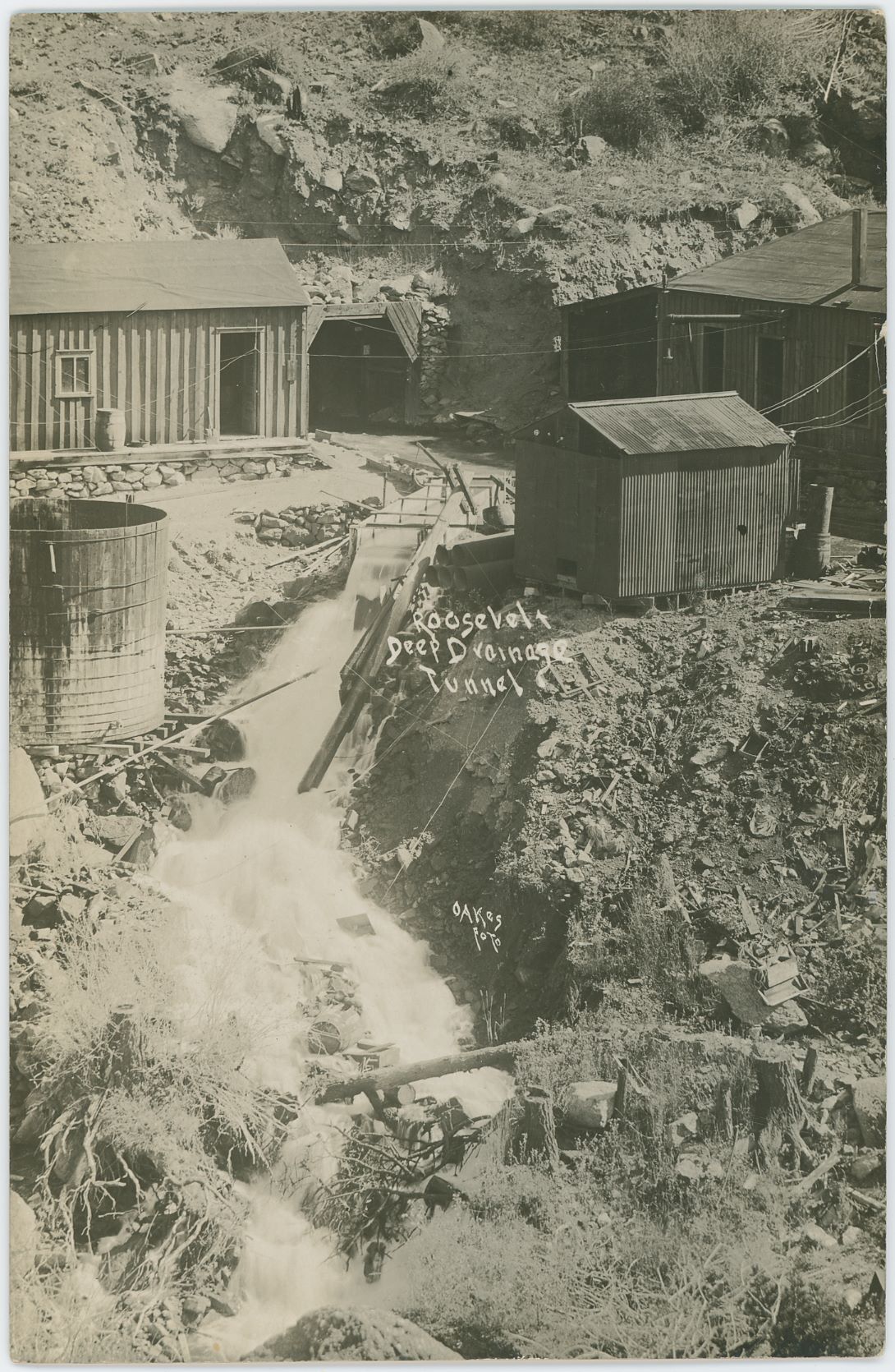
View flow of water from the Roosevelt Tunnel.
This coarse-grained granite forms the major portion of the broad plateau stretching southward from Cripple Creek, but the fine-grained granite becomes prominent in the region cut by the canon of East Beaver creek. The same gneissoid character is well exemplified in Eight Mile canon, where it shows the relationship to the massive granite. At the time of my visit (Aug. 25, 1909) the drainage tunnel had just crossed a small fissure through whose gaping walls a small stream of water is now flowing. Save for this recent flow, which probably marks the beginning of the drainage of the district yet to come, the tunnel workings are dry and the granite is exceptionally massive for gneissoid types and has but few joint planes.
High Explosives Used
The abundance of biotite (black mica) in the rock renders the granite elastic, and this elasticity interferes with the breaking of the rock. The method of overcoming this difficulty is to increase the per cent, of nitroglycerin in the blasting powder, and also to add gun cotton. Such an explosive shatters the rock much more effectively than the ordinary, dynamite used in mining. A. S. Pearce, the superintendent, informed me that he was using powder composed of 92 per cent. nitroglycerin and 8 per cent. gun cotton. This compound he found the most satisfactory explosive for gneissoid granite. This explosive is used in the center cuts while lower-grade powder, some containing 40, some 50 and some 60 per cent. of nitroglycerin, is used for the balance of the ground.
The tunnel is 10 ft. wide and 6 ft. high, with the roof and sides well squared up throughout. The intermediate shaft is 607 ft. deep, and was sunk in solid granite from top to bottom. It hits the tunnel exactly, and from the bottom Mr. Pearce drove breasts both ways, to the south to meet the adit and to the northwest to cut under Beacon hill and into the Cripple Creek mining area. The junction of the two headings (the adit being driven in conjunction with the intermediate south drift) was made after the bore had extended about 2000 ft. south of the intermediate shaft. It was found that the alinement was exact and grade perfect, the junction being so accurate that unless one examined the direction of the drill holes it would be impossible to find where the two headings met. The grade of the tunnel has been kept as low as possible, with just slope enough to carry the water toward the adit. This is 3 in. in 100 ft. (54 per cent.).
Leyner drills are used and have been found satisfactory; they drill rapidly and do not get out of order readily. They use hollow drill steel, and water is fed to the cutting edges. The holes are 2½ in. in diameter at the collar and 1½ in. at the bottom; the depth is from 7 to 9 ft. Two men are required to run each large machine used in the heading, and three eight-hour shifts are employed. The ventilation of the tunnel is remarkably perfect, and is maintained by a 2-ft. pipe laid on the right side of the tunnel floor. The smoke from a blast in the tunnel breast issues from the tunnel shaft in about three minutes after traveling about 3000 ft. horizontally. All waste rock is now hoisted through the intermediate shaft. The buckets are automatically dumped into an ore car, and only one man is required at the surface to remove all the waste lifted from below. A 3x6-ft. waterway is cut in the tunnel by a separate machine on the side opposite the track.
Time Required to Drain District
At the present writing the tunnel breast is directly under the summit of the first hill south of Beacon hill and between Gold and Arequa gulches. This tunnel ought to strike the phonolite plug of Beacon hill about 2000 or 2500 ft. farther on. When the tunnel strikes this dike or plug and enters the volcanic zone to the northeast, the drainage of Cripple Creek mines will begin but it will require time to drain the district at so great a depth. It is thought that the tunnel will be finished within the next eight or nine months, and, unless some unforeseen difficulties arise in the work, it is likely to prove a record for this size tunnel in granite rock.

Method of Drilling and Order of Blasting. Roosevelt Tunnel
The accompanying diagram shows the relative position of the bore holes used by Mr. Pearce in breaking ground at the breast of the tunnel, the numbers indicating the order of blasting. Twenty-six holes are drilled and these are so directed and fired that much of the waste is thrown to one side as it breaks, greatly facilitating its quick removal while the next shift is commencing operations.
Since the above was written the report of the boring for August and September has reached me, and Mr. Pearce states that his average during 10 months is 361 ft. 4 in. per month. During the mouth of August he made 410 ft. This distance was drilled in spite of the fact that he lost 56 hours from the disabling of the electric plant, through washouts down the creek. In September, with a loss of 108 hours, he drove the heading 399 feet.
Other Tunnels
In conclusion, a brief statement of the existing tunnels of Cripple Creek may be interesting. Every tunnel driven in Cripple Creek for drainage purposes has been a success. This is also true of other tunnels of the district not driven for drainage purposes;
for example, the Blue Bell tunnel, which was the first in the district. Its adit was in granite at an elevation of 9335 ft. above sea level and about 15 ft. below the original water level of the region. The tunnel had a maximum flow of 200 gal. per min., and the flow continued for several years.
The Ophelia tunnel, cutting the granite at the west base of Gold hill, has an elevation of 9268 ft., and when 2600 ft. in length is reported to have had a flow amounting to 2100 gal. per min. According to Lindgren and Ransome's latest report on the geology of the Cripple Creek district, this tunnel water came entirely from breccia in fissure zones connected with the main volcanic neck. This tunnel became dry in 1898 with the drainage of the Standard tunnel which had been under construction for about two years previous.
The Standard tunnel is in Gold run, west of Beacon hill, and lies at an elevation of 9027 ft. Its objective point was simply the volcanic plug of Beacon hill. When this tunnel struck the shattered phonolite zone a flow of from 16,000 to 18,000 gal. per min. was maintained for a long time. The ultimate length of this tunnel was 2800 ft., and it was of great value in lowering the permanent water level of Cripple Creek mines.
Still lower is the Newell tunnel which enters Grouse hill at 8930 ft., but it never reached the Beacon hill phonolite, and its face, although 119 ft. lower than the Standard tunnel, never yielded such a large amount of water.
The El Paso tunnel was, until the present Roosevelt project began, the lowest and most important drainage tunnel of the entire district. Its portal was at an elevation of 8783 ft., and its effect upon the water level of Beacon hill and adjacent mines was immediate.

Ransome's Diagram of Water Levels and Drainage Tunnels In The Cripple Creek District
Countryman and Jaquith estimated the total flow of this tunnel up to Jan. 1, 1905, at about 3,550,000,000 gal. of water. It is still discharging a large amount of water, showing that the overlying-rock water is not yet exhausted.
The accompanying water-level table is from Lindgren and Ransome's report (Professional Paper 54, U. S. Geol. Surv.), with the addition of the position of the Roosevelt tunnel, not included in this report.
Work was begun on this tunnel May 11, 1907, when Lieutenant-Governor Harper pressed the electric button which started the machinery for drilling. The amount subscribed was $760,000.
Shortly after the work commenced the contract was thrown up, but was reassigned to A. E. Carlton at $28 per ft. The entrance of the tunnel is in Gatch park, below Cripple Creek, near a place known as "Window Rock."